National Park of American Samoa: South Pacific Rainforest & Reef

Updated: 5 days ago
American Samoa National Park Intro
I came to American Samoa National Park expecting a beach and found a working landscape: steep green ridges, a reef a few strokes off the sand, and villages whose land the park sits on. Salt and wet leaves hung in the air from the first step off the plane.

Rainforest, coral reef and village life sit within a few miles of each other here. On the trail inland the canopy closed overhead, the ground was slick with last night's rain, and fruit bats flapped slowly over the treetops in broad daylight. Birds called from every direction, and the humidity soaked through my shirt within minutes.
Underwater was a different world. Corals in every shape crowded the sea bed, and fish moved through them in schools. Snorkeling in that warm, clear water made the afternoon slip by.
What stays with you is the people as much as the place. Samoan culture is part of the park, in the songs drifting from village churches on Sunday and the food cooked over hot stones. One evening the sun dropped into the Pacific, the sky went orange, then red, and then the stars came out thick over the ridge. I left carrying the quiet, the green ridges and the warmth of the people.
Introduction and Geography
The park is not one block of land. It is split across three volcanic islands in the South Pacific: Tutuila, Taʻū and Ofu. Each unit combines steep forested slopes, rocky coastline and fringing reef, and the mountains drop to the sea with almost no flat ground between.
Tutuila is the main island and home to Pago Pago, the territory's harbor town. Taʻū and Ofu lie farther east in the Manuʻa group, reached by small plane or boat on limited schedules. Distance and weather shape every plan here, so build in slack days.
The topography does the work of a trail map. Ridges run steeply down from the high ground, streams cut narrow valleys, and the coast alternates between sea cliffs and small pockets of sand. Nothing is flat for long, so even short distances on the map can take a long, sweaty grind on foot. Roads hug the coast where they exist at all, and most of the interior is reached only by trail.

American Samoa Fast Facts
This is the only US national park south of the equator, and much of it sits on land the park leases from Samoan villages.
Location: Parts of the islands of Tutuila, Taʻū and Ofu in American Samoa, in the South Pacific
Established: Authorized as a national park in 1988
Land: Leased from the villages, who still own it and keep their traditional ties to it
High point: Lata Mountain on Taʻū, about 3,170 feet, the highest point in American Samoa
Signature features: Paleotropical rainforest, coral reefs and flying foxes, the large fruit bats the park was created in part to protect
Top Attractions at a Glance
Ofu Beach: A long, quiet beach with a healthy coral reef starting just off the sand
Mount ʻAlava Trail: A ridge hike on Tutuila with views over Pago Pago Harbor and Rainmaker Mountain
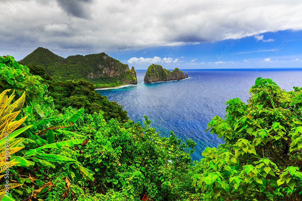
Pola Island: A sheer sea stack off the north coast of Tutuila near the village of Vatia
Taʻū: The park's wildest unit, with rainforest running from the coast up toward Lata Mountain
Pago Pago Harbor: The deep, mountain-walled harbor where most trips begin
Tutuila and the Manuʻa Islands
Tutuila is where most visitors spend their time. The ʻAlava ridge trail is a steady, humid climb through forest, and the payoff is wide-open views over the harbor and out to sea. Expect roots, mud and switchbacks rather than smooth tread, and start early so the climb stays cooler. Bring more water per person than seems sensible, because the humidity drains you faster than the mileage suggests. Vatia on the north coast gives you the sea cliffs and Pola Island, best seen from the shore with the surf booming below.
Ofu and Taʻū take more effort and reward it. Ofu's reef is the draw, a place to snorkel in calm water close to shore. Go at a leisurely pace, watch the tide and the current, and never swim alone. Look before you get in: note where the water moves, where the reef shelves off, and where you will get out. Taʻū is the quiet one, with forest, cliffs and few people. Check with the National Park Service before you go for what is open and how to arrange the trip.
Plan on slow days. A single trail, a single swim and a long afternoon in a village-side shade spot is a full day here, and the islands reward people who stop trying to cover ground.
Best Times to Visit
The drier season, roughly May to October, brings more sun and calmer seas for snorkeling and boat trips. The wet season, November to April, is hotter and rainier, and tropical cyclones are possible. Expect heat, humidity and rain showers any time of year.
Trails turn to mud fast after rain, so an early start helps: mornings are cooler and usually clearer. Humpback whales pass through in the southern winter, which overlaps the drier months. Flight and boat schedules can shift with weather, so keep your dates flexible.
Seasons here are less about snow and sun than about how much water is on the ground and in the sea. In the wet months, streams run high, trail crossings get sketchy and the sea can turn rough enough to cancel boats. In the drier months the reef is usually easier to read and the walking is kinder, though a shower can still land at any time. Whenever you go, carry a rain shell and treat any forecast as a rough guess.
History and Culture of American Samoa
Polynesian voyagers settled the Samoan islands about 3,000 years ago, and Samoan culture has deep roots here. Fa'asamoa, the Samoan way of life, centers on the extended family and the village, led by matai, or chiefs. Tutuila came under US control in 1900 and the Manuʻa Islands, including Taʻū and Ofu, in 1904.
Those first peoples read this land closely. They knew which ridges held good soil, which reefs fed a village and which forest plants worked as food, tools and medicine. Much of that knowledge is still passed down within families, and it is a big reason the forest is in the shape it is in. Walk through a village and you will see how closely daily life follows the same rhythms: shared meals, church on Sunday, and rest observed with real discipline.
From Village Land to National Park
Congress authorized the National Park of American Samoa in 1988, with support from scientists worried about the rainforest and its flying foxes. Instead of buying the land, the federal government leases it from the villages, so the park protects both the forest and the people who have looked after it for generations.
Ask First
Much of the park crosses village land. Ask permission before you swim, picnic or take photos near a village, dress modestly, and keep Sundays quiet.
Wildlife and Ecology
The park protects one of the few paleotropical rainforests in the United States, the kind of forest that stretches from Southeast Asia across the South Pacific. Two kinds of flying fox fly over it in daylight, and seabirds nest on the sea cliffs.
Flying foxes matter beyond the show. They carry pollen and seeds between trees, which keeps the forest regrowing, especially after storms knock it back. Watch for them in the late afternoon and early morning, and keep your distance so they are not disturbed.
The forest itself is layered. Tall trees hold the canopy, ferns and vines crowd the middle, and the ground stays wet, dark and loud with insects. Stand still on a trail for a few minutes and the bird calls sort themselves out: some close, some far down the slope, all of them hard to spot through the leaves. Binoculars help, and patience helps more.
Offshore, the coral reefs hold hundreds of kinds of coral and fish, green and hawksbill sea turtles feed on the reef, and humpback whales pass through in the southern winter. Coral is fragile and slow to recover, so keep fins off the reef, don't stand on it, and wear reef-safe sun protection. Float flat and kick gently in shallow water, since a single careless kick can break coral that took years to grow.
Plan Your Visit
Getting here takes planning: most visitors fly into Pago Pago on Tutuila, and flights and boats to Taʻū and Ofu run on limited, changing schedules. Check the National Park Service website for current conditions, trail status and cultural guidelines before you go.
Pack for heat and wet: a rain shell, quick-drying clothes, grippy shoes, a mask and snorkel, and plenty of water per person. Stay on trail, pack out everything you bring, and treat village land with respect.
A field-tested loadout keeps the trip simple:
A headlamp, since dark falls early near the equator
Sturdy shoes with real grip for mud and wet rock
A dry bag for phone, papers and spare clothes
Insect repellent and sun protection that is safe for reefs
Cash and small gifts of thanks for hosts, as local custom suggests
Leave room in the schedule for people. A greeting, a few minutes of conversation and a willingness to follow local guidance will open more doors than any map. If a host or ranger tells you a spot is closed or off limits for the day, take it at face value and turn around.
For the full picture of American Samoa, use these companion guides:
American Samoa National Park Travel Guide: getting there, village etiquette, where to stay and the best hikes
American Samoa National Park Highlights: the top sights at a glance
American Samoa National Park Reflections: the islands in a quieter, more personal light
🌲 WILD DIRT OFFICIAL TRAILHEAD: National Park Field Guides & Adventure Gear — Gear up for the backcountry with our sustainably crafted trailhead apparel, field guides, and waterproof topographic trail maps. [Explore the Collection →]
Sources
NPS & Government

